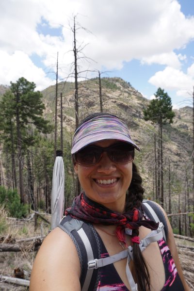
What a year this has been! I have been kept quite busy by my consulting company, Trails Inspire, and sadly have not posted much on Sirena’s Wanderings this year. However, this post will catch you up on what’s been going on, there are many links to follow as well to articles I’ve written or appeared in. I thank all the readers that have followed me for the past eight years I’ve written this blog and those who find my posts a resource and inspiration for their hikes.
A Grand-Canyon sized thanks to Gossamer Gear and Huppybar for their support of my adventures! If you’d like more frequent updates on where I’m wandering, follow me on Instagram at @desertsirena. Here’s my favorite shot of the whole year, condors J4 and 02 playing queen of the rock in Marble Canyon. Now on to a look back at 2017!

Condors playing Queen of the Rock
At the beginning of the year, I returned to volunteering at Wildlife Rehabilitation Northwest Tucson. I had taken a break for about a year or so and was so happy to be back! Volunteering there is one of my favorite activities and I am so fortunate to get to specialize in working with raptors – hawks, owls and falcons.
I filed the official paperwork in January to form Trails Inspire, LLC, my consulting business. Trails Inspire promotes the outdoors through photography, public speaking, freelance writing, and trail project management. Thanks to Wendy Lotze for designing my beautiful logo! Visit the website to learn more – I am currently booking speaking and writing gigs for 2018, contact me at sirena@trailsinspire.com. We’re also on Instagram and Facebook.
January 25th marked the 20th anniversary of my accident, when I was hit by a truck while walking across the street. That moment changed my life forever and I wanted to commemorate it with an outing in the Mineral Mountains with my friends Wendy and India. They were very good sports about it even though temps dipped into the 20s.

Hiking up to the ridge
February
I took a roadtrip from Chicago to Tucson with my dad and we entertained ourselves by using the Roadside America website to find attractions to visit along the way. It even made Nebraska interesting, a feat I formerly thought impossible. We saw the World’s Largest Buffalo Nickel and Ball of Stamps, historic sites, and sculptures ranging from epic to ridiculous.

World’s Largest Ball of Stamps

Picketpost Mountain

Perfect weather for a birthday hike!
Backpacked the first 60 miles of the Sky Island Traverse with Amanda “Not a Chance” Timeoni from Cochise Stronghold East through the Dragoons, over to the San Pedro River and followed the river down to the San Pedro House. I loved hiking among the giant cottonwoods of the San Pedro and there were lots of interesting side trips along the way to see archaeological sites and historic structures. I managed to hike a 20-mile day in spite of being in month five of my fibromyalgia flare. It was a triumph that made me feel better mentally if not physically. Chance was a great hiking partner and I really enjoyed her company. She’s hiked over 14,000 miles on long distance trails since 2009.

Stunning Cochise Stronghold

Hiking in the San Pedro River to stay cool (and because splashing through the water is fun!)
I attempted again to hike from South Bass to Hermit in the Grand Canyon, the hike I’d been helicoptered out of with a torn calf muscle the year before. Alas, the roads were muddy and we couldn’t get to the trailhead so I hiked the Escalante Route from Tanner to Grandview again. Not a bad plan B – the Escalante Route is beautiful and there was a prolific wildflower bloom that was unlike any I’ve ever seen in the Canyon!
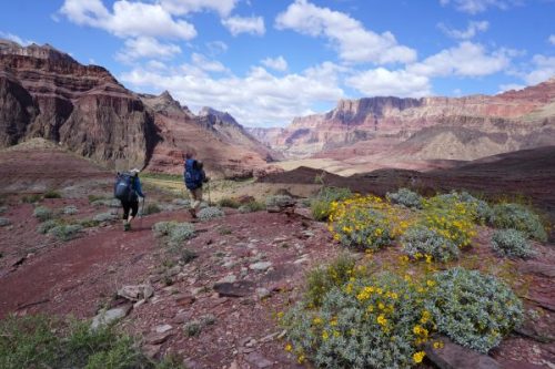
Spectacular views on the Tanner Trail

India and me at the Unkar Overlook
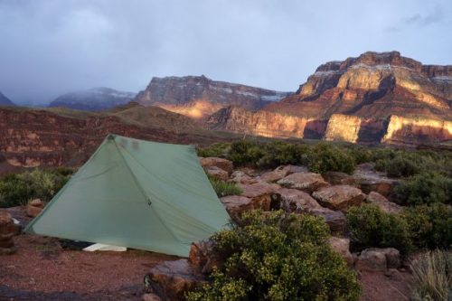
After the rain came the spectacular sunset light show

While my hiking companions sleep, I play with lights
Sadly, upon hiking out of the Canyon, I learned that the Wildlife Rehab had suffered a devastating fire that burned parts of the facility and resulted in the deaths of over 30 of our birds. The saddest part was that three of our educational animals, who we’d had for a decade, perished in the fire. Heartbreaking.

Aftermath of the fire outside

The bird room after the fire

In Silver City, New Mexico, I gave a talk on Hot Weather Hiking Tips at the Continental Divide Trail Kickoff and also published an accompanying article for the American Long Distance Hiking Association – West.
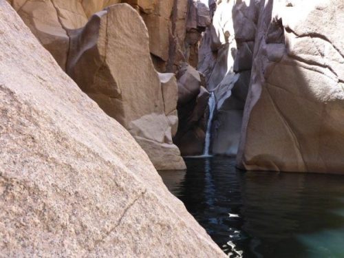
Canyoneered the Salome Jug in the Sierra Ancha with Meg and Russ Newberg. It was a gorgeous, sculpted pink canyon with lots of fun swims.

Salome Jug with Russ and Meg
Salome Jug – Photo by Russ Newberg

Trail maintenance with Arizona Conservation Corps

Oracle State Park
My nephew Gage went with me on his first backpacking trip, I chose Hutch’s Pool and he did great! It was a toasty hike in but the swimming made it all worth it.

Gage on his first backpacking trip

Hutch’s Waterfall
June
In June I started my company’s first big contract – to develop a community trails Master Plan for the Town of Tusayan, Gateway Community to the Grand Canyon and Arizona Trail. I traveled to Tusayan to meet with local business and landowners, the Kaibab Forest and Grand Canyon National Park. After work, I got to visit the Canyon and camp in the forest, it was amazing!
At the Wildlife Rehab, work continued on the facility and I put together a fundraiser event – After the Fire – to supplement the donations that were coming in online. It was a wonderful event at Sky Bar with fantastic entertainment and people really enjoyed meeting our remaining educational animals.

MoJo Grass

Nancy, Citan and Janet Miller

Marjani

Sirena and her dad, Budh Rana – photo by Levi Davis
Right before the monsoon rains comes Saguaro fruit season and this year was incredible – so much fruit! I harvested, dried and made plenty of fruit leather to last the rest of the year.
I visited Aravaipa Canyon for a leisurely trip with lots of hanging in the hammock, coloring, writing and listening to music. It’s always a gorgeous destination and the trip revitalized me for the whirlwind that was the rest of the month.

Aravaipa Canyon
Florida Trail

Pusch Peak

Arizona Governor’s Conference on Tourism

Women Who Lead panel

Liz Thomas and me
After developing and getting responses on a public questionnaire, I held a public meeting for the Tusayan Community Trails Master Plan, which also meant that I got to visit the Canyon again.

Herd of Elk near my camp in Kaibab National Forest

Huppybar in its natural environment

Wilderness of Rock
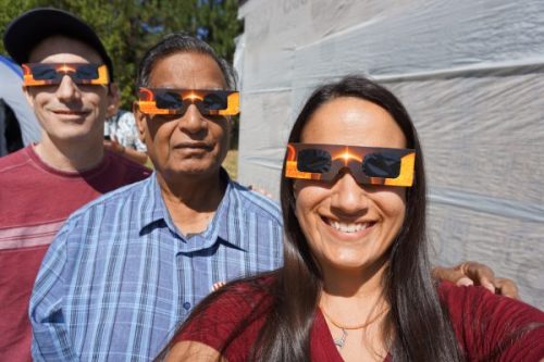
Brian, Dad and me ready for the eclipse

Bateleur Eagles from Africa
Took Gage on an overnight to Josephine Saddle in the Santa Ritas and we also summitted Mount Wrightson. Wrightson was my first big peak and I was excited to share the feeling of triumph with my nephew. He absolutely loved it and was amazed at the views and accomplishment. We had an epic sunset on the way back to our camp.

Summit of Mount Wrightson – 9456 ft.

Sunset on Baboquivari from the Baldy Trail, Mount Wrightson
Meadow on the new Tusayan Trail system

Working laying out trail with Mark Flint in Tusayan

Tusayan Sunset
Back to adventuring, I had always wondered what Upper Romero Canyon looked like and finally got to see for myself. My buddy Russ and I canyoneered down sculpted granite corridors and rappelled down waterfalls. It was good training for my upcoming big Grand Canyon trip.

Canyoneering Upper Romero Canyon

Canyon Tree Frog

Riding in the Santa Ritas

Force of Nature: Women Who Inspire – MC Lisette Wells-Mackovic, Backpacker (me), Ultrarunner Laura Swenson, Mountain Biker Veronique Pardee, Rock Climber Jenn Choi, Equestrian Carrie Miracle-Jordan

October
My friend Heather “Anish” Anderson came to visit with her boyfriend Adam after they’d both hiked almost 4000 miles on the Oregon Desert Trail, Colorado Trail and Continental Divide Trails. Check her Instagram @anishhikes, she’s always up to amazing things. After taking a couple days off, they were ready to hike so we backpacked from the top of Mount Lemmon out to Sabino Canyon so I could test my knees for my Grand Canyon trip. We spent the night at Hutch’s Pool and had a great time and the knees were ready to go!

Pistachio, Anish and me on Mount Lemmon

Tusayan Trails Master Plan

Butte Fault from the helicopter, Awatubi/Sixtymile saddle below.

Nankoweap Creek

Looking back at Nankoweap Butte

Awatubi-Sixtymile Saddle (same as in the aerial photo)

Sunset at Lava/Chuar
November
I grew up in the Chicago suburbs, two houses away from my best friend Kristin. We met when I was four and spent our childhood exploring together. My mom was forever sending her brother looking for us in the patch of woods by our house. I moved away in 1994 but we’ve stayed close all these years across the miles. Our lives couldn’t be more different, and she came for a visit to experience a vacation like none she’d had before. I set up a camping and hiking tour of many of my favorite places in Northern Arizona and we had the absolute best time!!
We started out with a night in Flagstaff, then I got to take her to see the Grand Canyon for the first time. It was such a blast, doing all my favorite things, and seeing Kristin experience them with fresh eyes. She was a great sport, and I took her camping in Marble Canyon and to the Navajo Bridge and Lee’s Ferry. The highlight was watching the California Condors play king of the rock, I looked them up and they are both females, born in 2011 and 2013. I have never gotten a chance to photograph them in action before other than soaring way above. We finished the trip with a hike on the Arizona Trail in Flagstaff and then she was back to Chicago. We’re already plotting her return.

Marble Canyon dance party

Hi there!

Training a Great Horned Owl

December
Trails Inspire and I were featured in Phoenix Magazine’s December issue in a wonderful article by Mare Czinar.

Redwall Overlook, Tanner Trail

Finger Rock

Dad and me in Cienega Creek

Buster Mountain Holiday Hike


 is still a ways away")


