The original plan: 23 days of backpacking through the Grand Canyon from the North Bass Trailhead to Whitmore Wash, October 1-23. At the beginning of the year, I had planned to hike a big chunk of the Grand Canyon in October. I am working on hiking the length of the Canyon in sections, it’s a project I will be chipping away at for the next several years. I agonized over maps choosing a route and itinerary, put my permit request in four months in advance, placed food and supply caches via a friend’s river trip and trained all summer long to be in shape. So many friends helped me plan- shout out to Rich Rudow, Chris Atwood, Jamie Compos and especially Chris Forsyth for answering my endless questions.
Even before I got on the road, I ended up having to change my itinerary due to impassable roads and Chris and I getting sick and having to delay our start. The theme of this entire trip was “be flexible and enjoy whatever ends up happening”. Thankfully the illness was short-lived and the next day we were able to hike in via the Bill Hall Trail from Monument Point. Finally!
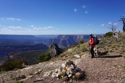
Monument Point Trailhead taking Bill Hall Trail to Thunder River

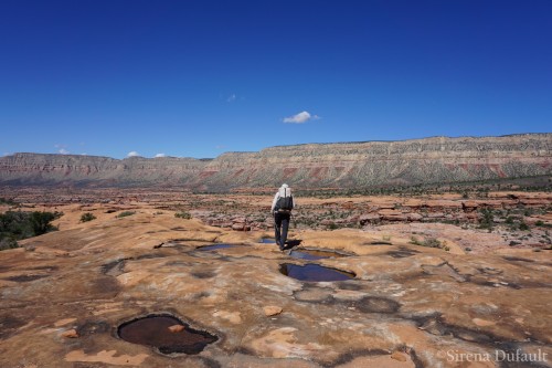
Hiking down to the Esplanade
I was so excited to finally be at the rim of the Grand Canyon on the cusp of my big adventure, fresh scenery ahead. Chris and I had a great hike down and I was pleased to see that my leg had rehabilitated well from my calf muscle tear that had caused my helicopter evacuation from the Canyon just six months prior. There was water in the potholes on the Esplanade and then the trail descended a jumble of Supai blocks and Redwall to Surprise Valley. True to form, Surprise Valley was hot and I was glad to have my umbrella. The descent to Thunder River promised cool shade and water below and we took a much-needed break at the falls.
Checking the potholes, often times they are the only water source on the Esplanade layer

River view and Surprise Valley

Above Thunder River in Surprise Valley

Thunder River
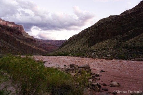
We pushed on past the upper campsite, hoping we’d get the sketchy part of the descent over with before dark. We made it with plenty of time, which was good- don’t think I’d want to hike that part by headlamp as we saw some rafters do later that evening. This was the location of my first cache, which was just a mini bucket with two days of food in it and some coconut water for a treat. It started to rain and I set up my tent, The One by Gossamer Gear. The company had sent it over for me to try on my trip and it set up easily with rocks and my hiking poles. As is usually the case, it stopped raining as I got it set up. Tapeats Rapid on the Colorado River provided a great backdrop and I was happy to sleep near the roar of a rapid once again. Only I didn’t sleep. It was one of those awful nights where you have your eyes closed, but never actually rest.

Chris and me in Tapeats Creek

Tapeats Creek and the muddy Colorado

Descent to Tapeats Creek
Tapeats Rapid
The next morning, I was happy we had a short day ahead of us and had hopes of a siesta for my sleepy self. We said hi to the boaters and they took my mini-cache bucket out for me. Chris and I chose the low route that goes along the river toward Deer Creek, it was so much fun to walk where I’d only boated before. There was a short scramble down into Bonita Creek that was pea gravel over bedrock, not my favorite combo. We hiked near the Granite Narrows and the low path split into two. We took the low route that stayed just above the narrows and saw the “piano” up close. There was a great overhang for a break with some ancient walls and then we turned the corner and saw the spot that we’d read was exposed. From a distance, it looked impossibly thin with a scary drop off, but as we got up to it, there was a solid rock shelf that gave passage along the cliff’s edge.

Collared Lizard

Me with the “piano” above the Granite Narrows, 76 feet across at river level

Chris headed for the thin spot on the low route to Deer Creek

Deer Creek
The route eventually climbed and met up with the other route over the Cogswell Butte saddle, then down into Deer Creek just above the Patio. We set up for an extended break and I blew up my mattress for a siesta. Later that afternoon, the river party showed up and we teased them about arriving on foot sooner than they’d floated down. The Patio is a wonderful place no matter how many times I’ve been. It was gratifying to have gotten here on a backpacking trip.

Deer Creek Patio
Eventually, Chris and I descended to the main Deer Creek Falls to get water before hiking along the shore to find a camp. What a place. When we left Deer Creek, the river level was low and so we stuck to rock hopping along the shore. There were sand banks to climb and as I stepped on one of them, it gave out and I jammed my left thumb hard into the ground. Searing pain shot through my hand and by the time we got to camp, I was pretty worried. What would a messed-up thumb mean for the rest of my trip? I was supposed to be canyoneering and scrambling as part of my route. Chris was going to be hiking out the next day and I was going to do the next four days solo. I was so nervous- about my thumb, about being solo, about the enormity of the trip, about the upcoming travel which was rockhopping along the broken-up jumbled shoreline for 7 river miles to Kanab Creek. Which is probably why I once again got absolutely no sleep for the second night in a row.

Night 2 camp downstream from Deer Creek

Scorpion Relocation Services
The next morning, when Chris was getting ready to leave I felt awful. Shaky, exhausted, thumb puffy and painful. I’d made a decision in the middle of the night that I was going to try to catch a boat ride with the rafters we’d seen the last two days. They were camped just downstream across the river at a camp called Pancho’s Kitchen that I’d stayed at many a time during river season. I packed up and hiked down to where they could hear me. Lucky for me, I’ve got Italian lungs and they had no problem hearing me get their attention. “Can I get a ride to Kanab?” I yelled. They came over to my side of the river and picked me up. The boatman was Guy and his friend Joe was also in the boat and they helped me get my pack strapped down and PFD on.

Getting ready to thumb a ride downriver

Success! Caught a ride with Guy and Joe

On a boat again…
I couldn’t thank them enough! In return, I told them that they had a former river guide on board and told them stories about the river and answered their questions. I’d always worked the big motor rigs so it was a lot of fun for me to be in a small, quiet oar boat. I watched as the rough and rugged shoreline passed by. So glad to have the option to not be rockhopping, and the day was a hot one. I’ll return to do it some other time. We reached Kanab Creek at 11am and Guy and Joe waited to make sure that I could locate my cache. I am so grateful that they were able to give me a ride and wished them best of luck in the rapids ahead. They joked that they’d done good for their river karma by giving me a ride.

Joe and Guy waited to make sure I located my cache at Kanab
I got my cache bucket and found some clear water in the drainage between the creek and the river. Moved down to my own personal-sized beach downstream and set up my umbrella, sleeping pad and pillow for the rest of the day. This cache was a large one with resupply for my food, fuel and first aid and some fun stuff like special treats, coconut water and party lights for camp. It was a fantastic day catching up on my sleep. Spent a bunch of time photographing the Milky Way.

That doesn’t look good…

This setup provided me with shade all day long

Some of the treats I included in my cache

Private beach at Kanab perfect for catching up on my sleep

Cached some party lights for nighttime fun!
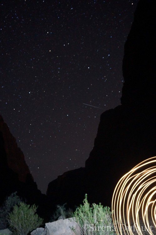
Meteor and light show

Milky Way over the Grand Canyon
The next day, I had a decision to make- I was supposed to have another layover day at Kanab and then hike upcanyon to meet up with Chris and our friends Shannon and Jillian McCumber to go out Kanab onto the Esplanade and over to the 150 mile trailhead. We were coordinating the meetup via my InReach satellite messenger. I decided I didn’t need another day off so I got packed up to start hiking up Kanab Creek. As I went to put my pack on to leave camp, I wrenched my thumb again. Crap. My thumb combined with uncertainty about whether or not we could make it to 150 on the McCumber’s schedule caused me to change the itinerary to hiking out the Flipoff route, a tributary of Kanab Creek. I realized that no matter what plans I’d originally had that the Canyon had other ideas and I had to go with the flow and just be glad that I was spending time exploring my favorite place. I was much happier after letting go.

Kanab Creek
I started hiking up Kanab Creek around noon and the canyon had recently flashed, leaving deep pools and sucking mud. It was tough to gauge how deep because you couldn’t see through the water, so I relied on my poles to help. I reached an area with big, flat Muav limestone ledges and set up for a break. After a while, I thought I heard voices. Sure enough, along comes a tour group with Wildland Trekking, out for a 6-day Kanab Creek out and back from Sowats Point. I wasn’t expecting to see anyone, though I had seen the group’s muddy footprints. They were heading the same direction as me and it was nice to know that someone else was there if I needed help the next day scrambling with my hurt thumb.

Relaxing on the Muav ledges in Kanab Creek

Walking the Muav ledges in Kanab Creek
I camped just inside Whispering Springs Canyon in a lovely little Muav amphitheater with the sound of trickling water lulling me to sleep. No problems with sleepless nights the rest of the trip.

Whispering Springs Falls

Muav ledge camp in Whispering Springs Canyon
The next day was challenging as there were quite a few places that required routefinding through boulder jumbles. I managed alright by myself, there were a couple of places where I lifted my pack up and climbed after it. There was a fine silt left by the receding creek that was very slippery, even with my sticky 5.10 Camp Four shoes.
I had three pairs of shoes on this trip. Yes, you heard me right- three pairs. I had planned on doing quite a bit of canyoneering and scrambling on my original route, so I had the Camp Fours. However, the Camp Fours weren’t necessary on most parts of my route and they were giving me plantar fascitis (heel pain), so I decided to bring my comfy Altra Olympus as well. And because I hate wearing shoes in general and had planned to spend quite a bit of time in camp, I had my 4oz foam camp sandals. I cut other weight where I could to make up for the extra shoes- they were worth it and I didn’t get any blisters. Even with 3 pairs of shoes, I was able to keep my weight of my pack down at about 32 pounds to start (with 2 days of food and 3 liters of water).
I ducked into Scotty’s Hollow for water and a lunch break and was thrilled to have a waterfall and pool to hang out at. This canyon was going to be our original exit route onto the Esplanade but I was glad we’d changed it- there was a lot of climbing and my thumb was not up to it.

Scotty’s Hollow

Flame Skimmer
I reached Showerbath Spring in time to get a shower while it was still sunny in the canyon. What a gorgeous place, it was great to see it for myself after having seen it in so many Hayduke Trail trip reports. I settled in and waited to see if Chris was going to meet me. He was hiking in Flipoff Canyon after dropping Shannon and Jillian off to hike in via Jumpup Canyon. I wasn’t sure he’d make it that evening and was prepared to meet up with him the next day if I didn’t see him. The tour group passed by and I chatted with the guides Stefan and Isaac. After it had been dark for a while I saw a headlamp and assumed it was one of the guides coming to get more water from the spring. Only it was Chris, hiking in the dark after an epic day coming down the Flipoff route into Kanab!

All clean!

Scarlet Monkeyflower

Tent is The One by Gossamer Gear

It was great to see Chris again and hear his tale of routefinding into Flipoff solo and subsequent hike to get to Showerbath Spring. We listened to music and watched the outrageously good star show.
The next day we had a leisurely start, all we had to do was go up to Jumpup Canyon to rendezvous with Shannon and Jillian and then find a place to camp. The going was easier in the creek above Showerbath, though there was still water flowing, even above the source of Kanab Creek. Remnants from the receding flood. There was smoke in the air from a fire on the rim. Chris and I found water in a pothole in Rattlesnake Canyon and dropped our gear for camp nearby. We hiked up Jumpup a short distance and waited on a rock till we heard and saw the McCumbers- so fun to meet up with friends deep within the Canyon! Unfortunately, Shannon was moving slowly on an ankle she’d sprained on day one of her trip. It looked painful and sore. We hiked to our camp and settled in for the evening.

Yay! We meet Jillian and Shannon in the depths of Jumpup Canyon

The next morning, the water had receded again and the creek above our camp was dry. We hiked up Kanab Creek and out of the National Park boundary into the Kanab Creek Wilderness and Kaibab National Forest. This is part of the area that would be protected under the Greater Grand Canyon National Heritage Monument, for more information and to sign the petition to urge President Obama to designate the monument, visit the link. Hard to believe that there are active uranium mines a short distance away on the rim. Here’s a map, click to enlarge:
We checked out a side canyon called Crack Baby by canyoneers. The base of the last rappel was beautiful and there was a pothole with water accessible to those willing to scramble around a chockstone.

Crack Baby Canyon
As we hiked up Kanab, the Redwall formation got shorter and shorter. We reached the Flipoff Canyon intersection and struck an appropriate pose. The canyon presented some small scrambles and soon we were at the Redwall/Supai contact. Jillian and Chris went to check out some cowboy junk and I took a step to stop and put my pack down for a break. As I did, the boulder I stepped on came loose and fell from its spot and I found myself falling and ended up with my head in Shannon’s lap. Lucky thing it was her lap and not the rock below it that my head landed upon. Scary how quickly things can go south.


Redwall/Supai contact in Flipoff Canyon
We took a long break at a delightful spot with cottonwoods and running water. The weather had been clear up to this point but we could see clouds mounting. A short time after we left the cottonwoods, it started raining. Lucky for us there was a great overhang for us to wait out the worst of it. We worked our way up the Supai formation, scrambling up or around some pouroffs. Close to the top of the Supai Chris spotted some rock art that we went to investigate.

Beautiful spot for a break in Flipoff Canyon

Waiting out the storm in an overhang

Supai Sandstone in Flipoff Canyon

Petroglyph and pictograph panel
And then we were finally on top of the Supai on the Esplanade and worked our way to some fantastic potholes filled with water near an overhang that held an old cowboy camp. The sunset was one to remember and Shannon and Jillian said it was entertaining watching Chris and I be the “sunset paparazzi”, running all over the place to get the perfect shot. After the rest had gone to bed, I spent some time doing long-exposure night photography with the Flipoff.

Out Flipoff Canyon onto the Esplanade, the top of the Supai layer where good camping and waterholes await

Flipoff Sunset Panorama

Stargazing and reflections
The next morning I found a bunch of sweet lithic chips from stone tool manufacturing in the overhang as well as some other artifacts and cowboy stuff. Then it was time to hike out the Flipoff Route. You could see the 1700 foot rock slide that covered the Kaibab, Toroweap and Hermit layers from our camp. It was going to be a tough one. There were occasional cairns and a path that had old horse poop on it. The footing got looser as we hiked up the slope. It was ok as long as I was heading uphill but traversing was uncomfortable.

Ancient stone tool fragments

Hiking to the exit, which is the big rockslide that covers the cliffs on the left


Gaining elevation and looking down on where we camped
There were one or two times when I had to will myself to take the next step. We had read about a climb in the Coconino, but never found anything that required us to raise packs like in the route description. More loose and steep uphill brought us to a crack in the Kaibab that led us to the top. Whew! I can hardly believe Shannon did all that on a bad ankle. She is tough!

Loose and steep, but it gets you out of the Canyon

Quick break before resuming our scree slope sliding out

Flipoff Route rim exit with bonus ominous bighorn skull

“Trailhead” by the wildlife guzzler tank far away from anywhere
Chris’ car was parked at the wildlife guzzler, a collection tank for water. I decided to go back into Kanab, Utah to plan the second part of my trip. I couldn’t go on with my original itinerary- not with my thumb the way it was. Also, I wanted to step back my mileages, what I had originally set out to do was too aggressive.
We drove back into Kanab and I decided that I’d take the next day off. Chris suggested we go do the tourist thing in Zion since I had never been. It was a surprising respite to the tough hiking I’d done so far.
Chris and I got Asian Fusion for dinner and he gave me his fortune that said “Attitude is a small thing that makes a big difference.” I put it in my first aid kit as a reminder. Little did I know how much I’d need that advice for the second half of my trip from Tuckup to Tuweep.


[…] « A Grand Adventure, Part 1 […]
[…] was all about the Grand Canyon! What was supposed to be 23 straight days ended up being one 8-day and one week long trip. It was just good to be out in such a remote area, seeing new parts of this […]
[…] on the Muav ledges in Kanab Creek, Grand Canyon (six months after my […]