Feeds:
Posts
Comments

Archive for March, 2014

March 24- 10 days after I began the Arizona Trail Trek, I was alone on the trail for the first time.

Dropped off on FR 4064, where I'd ended the day before

Dropped off on FR 4064, where I’d ended the day before

But before I get to the story of my hike, I just want to remind everyone about the exciting Arizona Trail Trek events happening this weekend in Tucson. Friday night, join me at Sky Bar at 536 N. 4th Avenue from 7-10 pm for the kickoff of our Indiegogo crowdfunding campaign with a special belly dance fundraiser event featuring music by Cobracalia and performances by Tucson’s most talented dancers! I may even trade trail dust for stage glitter for the evening…

On Saturday, I am throwing the first annual Arizona Trail Day in Tucson with guided hikes, bike and equestrian rides as well as fun activities in the afternoon at Colossal Cave Mountain Park. The hike is sold out, but there is still room on the bike and horseback rides. The celebration continues in the evening at La Sevilla Campground with food, live music, and Arizona Trail Ale. Visit www.aztrail.org for the details.

The past days had been a mix of leading people on dayhikes, backpacking with one person or another and interacting with LOTS of people at the Gateway Community Events in Sierra Vista and Patagonia. What a wonderful thing to have been able to reach so many people just weeks into my journey.

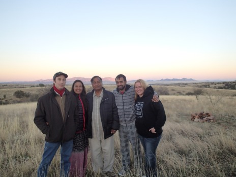
Add into the mix interviews for various media outlets and visiting with my dad, brother and his girlfriend who were in from Chicago, and I hadn’t had any time to myself on the trail.

Me and my dad

Me and my dad

This wasn’t just any piece of trail to me- I had been on the very first crew out here in October 2007 when the Las Colinas passage was just a line of flagging tape and pin flags out in the desert. My trail crew, The Crazies, built trail every other Thursday for years, putting in thousands of volunteer hours to make the Arizona Trail a reality.

Crazies in Las Colinas

Crazies in Las Colinas

When I hiked through here in 2008, there was only two miles of Las Colinas built and I teamed up with another Crazie, Lee Allen for an all-day bushwhack. 14 miles of getting stabbed by every type of poky thing in the desert, trying to follow the path the trail would eventually take through the rolling hills.

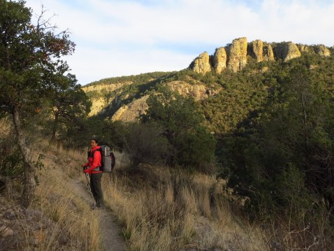
Now it was all trail, beautiful through the oaks and junipers, winding in and out of canyons. I crossed several gates, made to strict specifications of Laddie Cox, made to last lifetimes.

So fun to see gates that I helped install- great memories of building the trail abound on this passage.

So fun to see gates that I helped install- great memories of building the trail abound on this passage.

So nice to be alone on the trail- people ask me if I get scared and I often reply that I am as comfortable out here as I am in my living room. Just me and whatever it is that I want to do.

For example, in one canyon I came across the most adorable horned lizard, colored perfectly to match the surroundings. I picked him up and spent quite a bit of time taking pictures of it, then holding it in my hand. I pet its scaly back and it flattened into my hand and fell asleep. If I’d been hiking with a group, I might have taken a picture and moved on and missed this wonderful interaction.

Horned lizard hanging onto my umbrella

Horned lizard hanging onto my umbrella

A handsome fellow, he fell asleep in my hand.

A handsome fellow, he fell asleep in my hand.

As I descended in elevation from oaks and junipers to prickly pear and mesquites, more and more wildflowers appeared. I was stopped in my tracks by a hillside of yellow desert mariposa lilies and the trail was lined with pink and white fairy duster. It also got quite a bit hotter and set off my allergies. You see, I am allergic to the desert I love so much. Can’t even have most of the plants touch my skin, I break out in a rash. Oh well, that’s what long pants and sleeves and allergy medication is for.

Wildflowers!!

Wildflowers!!

I hadn’t gotten on the trail until the afternoon because I had to do a shoot in the morning for the video for the crowdfunding campaign, but still managed to make decent miles. I weighed my camping options and decided to stop before the end of the passage in a valley that shielded me from Highway 83 and houses nearby. It was right around Mile 100 of the trail, according to the maps and databook. I was treated to a spectacular sunset and a view of the Rincons and Catalinas, the next mountains ahead.

Sunset

Sunset

My Gossamer Gear Mariposa pack rocks!!

My Gossamer Gear Mariposa pack rocks!!

The next morning, I got on the trail with 15 miles to go until my pickup point at Gabe Zimmerman Memorial Trailhead north of I-10. I planned on zipping through it and being done by early afternoon. That was, until I met Terry.

Terry

Terry

I’d hiked a couple of miles to Twin Tanks and heard a horse. There was a camp underneath the tree and a man waved and said “Come say hi!”, so I did. Terry was also doing the whole Arizona Trail at once, on horseback. He’d started three weeks ago and was taking his time up the state with his two horses and two dogs. He made us a cup of coffee and I spent three whole hours visiting with him, trading stories with a fellow traveler on the AZT. I told him about the Arizona Trail Day happening on the 29th at Colossal Cave and he said he’d be there. It will be great to have him be a part of the festivities!

Hi little snake!

Hi little snake!

River taking a rest on Katie

River taking a rest on Katie

Heart shaped cactus pad was caught in Katie's tail

Heart shaped cactus pad was caught in Katie’s tail

Eventually, I had to move on to make it to Gabe Z. I was pretty sure that I wasn’t going to have any problems finding Passage 7, after all, I had written the description for this passage and the next in the new guidebook “Your Complete Guide to the Arizona National Scenic Trail”. It’s also pretty flat, and winds through ocotillo, creosote and mesquite.

The weather was overcast and I even got rained on for a little bit nearing I-10. I had my big wildlife encounter of the trip so far- five deer crossed my path right before the I-10 underpass.

My big wildlife encounter so far- five deer right by I-10

My big wildlife encounter – five deer right by I-10

Nearing I-10

Nearing I-10

Micro Chicken ready to go into the I-10 tunnel underpass

Micro Chicken ready to go into the I-10 tunnel underpass

Underpass selfie

Underpass selfie

I crossed under I-10 and as I hiked along the rim of Davidson Canyon, the ground was covered in tiny flowers that turned the desert yellow. I could see the green cottonwoods of Cienega Creek ahead and knew I was nearing the trailhead.

Parts of the trail were covered in tiny yellow wildflowers

Parts of the trail were covered in tiny yellow wildflowers

The Gabe Zimmerman Memorial Trailhead is a special place on the Arizona Trail, another piece that I helped to build. Zimmerman, a 30-year-old aide to U.S. Rep. Gabrielle Giffords, was killed along with five others in the January 8, 2011 Tucson shootings that injured Giffords and a dozen others. The trailhead and interpretive trail celebrates his life and love of the outdoors and Arizona Trail.

Arriving at the Gabe Zimmerman Trailhead

Arriving at the Gabe Zimmerman Trailhead

Remembering Gabe

Remembering Gabe

I was happy to see my dad waiting for me at the trailhead, he’s been such a great support these past two weeks. Nice to spend a couple of days at home before the AZT Trek begins again with the big event on Friday night at Sky Bar and Arizona Trail Day at Colossal Cave on Saturday. Come Saturday morning, I will hike with a big group of people from the Gabe Z. TH into Colossal Cave for a full day of activities, then in the evening I’ll be at the La Sevilla Campground for an evening of entertainment by Eb’s Camp Cookin’, food by It’s Greek to Me, and Arizona Trail Ale by the campfire.

What an experience the Arizona Trail Trek has been so far, I can’t wait to see where it takes me next.


Read Full Post »

It was my hope from the very beginning that  I’d be able to share a bit of the glory and adventure of Sirena’s through hike on the AZT.  After all, she’d become so much more than just a hiking buddy and fellow blogger over the last year – she was one of my closest friends.   The fact that I am insanely envious barely plays into it at all (wink).  So, when my schedule shifted about a bit and opened up an opportunity for me to not only join her for Passage 4, but to also get to guest-blog about our adventure, I grabbed at it.  An overnight on the AZT…with my celebrity friend…just the two of us and the foothills of the Santa Rita mountains on one of the most beautiful weekends of the year?  Oh yeah.  I’m in!

OLYMPUS DIGITAL CAMERA

Filming at the Patagonia Visitor Information Center

I met up with our roving woman of wonder in the small southern Arizona town of Patagonia for the AZ Trail Trek event on Thursday night.   With music by Jamnesia, Arizona Trail Ale from That Brewery in Pine and a beautiful evening provided by mother nature, it was a smash success.  Fudge and treats from the Ovens of Patagonia (can you say Key Lime Meringue?) kept the festivities going until after darkness set in.

IMG_0354

IMG_0359

A festive atmosphere in Patagonia

While I was camped out in the grasslands near my exit trailhead at Kentucky Camp, Sirena had secured accommodations from a pair of trail angels in their teardrop trailer just outside of Patagonia (thanks to Maggie, Patrick and their very friendly kitty).  Sirena’s connection with the folks in Patagonia is amazing, and she had even more help coming, from Helen who agreed to shuttle yours truly from Kentucky Camp to our starting point on Temporal Canyon road.  This warm support from the members of this active gateway community is a part of what will continue to make the Arizona Trail a great experience in years to come!

IMG_0362

Sleeping snug in a teardrop!

IMG_0002

Helen, Bear and Shadow see us off

Passage 4 of the AZT follows the Temporal Canyon Road in Patagonia for the first 13 miles.  For most through-hikers, road walks are similar to unwanted chores: often necessary, rarely enjoyed.  Sirena had taken care of the first 7 miles of the road walk the day before to speed things up, so we had only about 6 miles to go before we truly got off into the wilds.  Luckily, even road walking in this area can be scenic and rewarding.  Winding through the oak forests and over the pools of Temporal Gulch wasn’t such a horrible chore at all – and the terrain offered enough distraction to keep us contented as we hoofed along.

As road walking goes - this really wasn't bad at all!

Along the Temporal Canyon Rd.

IMG_0009

Water sources were surprisingly ample and clear considering the drought conditions. This little slot just off the road sported some inviting, cool pools.

Our favorite peaks with Temporal Gulch road cutting up

The road climbs into Walker Basin with Josephine (left) and Baldy (right) Peaks in the distance.

From here, you could see the road we walked winding down into the valley below

Looking back down into Patagonia from near the top of the road walk.


IMG_0025

The trail sign at Walker Basin looks as though it has seen better days.

Throughout our walk on the road, we were amazed at the amount of water that we were finding.  The spring boxes were full, and there was often a slow trickle in the bottom of the canyon.  Although it has been an unusually dry (and warm) winter and early spring in southern Arizona, it seems that a few well-timed storms have really helped out these riparian areas.  It’s unlikely that the pools will remain long without more moisture coming from the sky and soon – but it was a real treat to know that we would not have to worry about running dry on this particular piece of trail.

Once we turned off onto the Walker Basin trail and got back to our preferred single-track hiking, the mountains rewarded us with even better vistas and diversity.  Mt. Wrightson, the highest mountain in the Santa Rita range, is topped by Baldy Peak at 9,453 ft.  This barren, granite summit presides over the entire range like a patriarch, and it’s steep wooded flanks have always called to those seeking solitude and adventure.   Both Sirena and I have visited the summit on multiple occasions – but somehow it’s even more impressive to see the mountain this way – wandering about at it’s base staring up.   Although the Arizona Trail does not climb to the top of this range as it does with the Rincons and the Santa Ritas further north, it does provide hikers with an intimate experience with Wrightson just the same.

IMG_0034

The massive eastern flank of Mt. Wrightson and Baldy Peak

Posing with the peak

Our intrepid through hiker is dwarfed by the mountain

16 miles into Passage 4 (9 for us today), we arrived at Bear Spring.  Our initial plans were to camp near the spring, as Sirena had often wanted to but schedule often didn’t permit.  The spring is a beautiful spot – cold, clear water from the tank and a sycamore-studded stream babbling just down the hill in Big Casa Blanca Canyon.  There were some ideal tent sites near the creek, and plenty of trees for my hammock.  We took our hiking shoes off and dunked our feet in the icy creek,  filtered and drank our fill of the delicious water and considered our options.  It was still early in the day, with hours until sunset, and our feet now felt refreshed and ready to go again.  We decided that while the spring was an ideal spot, we’d take our chances on the trail ahead and keep moving just a little while longer.

Partaking in Bear Spring's bounty

Collecting water from Bear Spring

Flow in Big Casa Blanca Canyon below Mt. Wrightson

Looking up Big Casa Blanca Canyon from Bear Spring

Just past the spring was a wide, open campsite along the side of the creek where we found the Seeds of Stewardship group.  We knew they’d be in the area, so we were glad to find them happily settled in for the evening in the perfect spot.    The leaders and students were really enjoying the passage – particularly the ample water we were finding in the drainages – and they were excited to meet the celebrity through hiker in the flesh.  We spent a little while swapping stories and recruiting for future events before snapping a picture and heading back out.  It’s always great to see young people learning to love the outdoors!

IMG_0391

Sirena and the Seeds of Stewardship Group


My rising star doing what she does best!

Afternoon light hitting the walls of Big Casa Blanca Canyon

Beginning at Bear Spring, the trail follows a historic drainage feature called a “flume”.  This ditch was dug into the mountainside in the early 1900’s as a part of an effort to provide water to a gold mining operation in nearby Kentucky Gulch.  Water from Bear Spring was diverted into the flume and ran in the ditch for 2 1/2 nearly level miles to the next improvement at Tunnel Spring.  Because of this historic engineering effort, the trail feels almost dead-flat, and contours high above the steep floor of Big Casa Blanca canyon.  At one point, Sirena began telling me, it’s supposed to duck through a hole in the rock – but she missed the spot back in 2008 by accidentally taking the bypass built for equestrian use.  She was just finishing the story when we came around a corner and found the “hole-in-the-wall” – a small tunnel through the conglomerate rock that makes up the canyon walls.  Her excitement made passing up the Bear Spring camp 100% worthwhile!

IMG_0061

Between a rock and a hard place

As the sun got lower in the sky, we began to look for a spot to camp.  Since the trail is carved into the mountainside, we started to scan the ridges and slopes that ran perpendicular to the trail for a spot. I spotted a faint foot-path heading off onto one such ridge, and we followed it out to one of the finest campsites we could have hoped for.  A small fire ring, cleared spots for ground sleepers, trees for hammocks and drop-dead amazing views to the south, west and east.  We arrived just in time to settle in before the evening light show started, then made ourselves a modest fire and ate Thai green curry chicken and rice by its glow.  For girls like Sirena and I, it simply does not get any better.

We found a camp off the main trail on a ridge top with GREAT views

Mt. Wrightson casts a sunset shadow on the Mustang Mts.

The shadow of Mt. Wrightson falling across the Mustang Mountains

Whispy clouds make the BEST sunsets!

OLYMPUS DIGITAL CAMERA

Looking back at where she’d started a week before – the Huachuca Mountains

One of my best hangs ever.  Just perfect geometry - slept like a log!

Hammockers would call this a “perfect hang”

OLYMPUS DIGITAL CAMERA

Sirena got to spend the night under the stars and the morning looking back at the Huachuca crest

The next morning we didn’t get an early start (which is SO typical of us!), but we were on the trail in plenty of time to cover the 10 miles remaining to our base at Kentucky Camp.  We had more historic flume hiking ahead, followed by a series of small ups and downs along the historic water system, and ending with a short but wearing road walk from Kentucky Camp to my trailer just down the road.  We were low on food (Sirena’s finally got a through hiker’s appetite), and eager to get back before her family arrived at camp.  Never the less, we hardly hurried.  The trail is just too much fun to rush!

Throw one for me!

We call this “Throwing A Wendy”: check it out on Facebook!

Sirena makes her way across the flume on the opposite side of a drainage

Sirena hikes ahead around the contour of a minor drainage

IMG_0109

Overview of the flume system from the tunnel at Tunnel Spring

The sparkling Santa Ritas on a gorgeous day!

Panorama of the Santa Rita crest from Baldy to Mt. Fagan and McCleary Peak

Cool thing...on the Gardner Canyon Rd.

In Gardner Canyon

What exactly is this gate supposed to be stopping?

What exactly is this gate supposed to stop from passing?

IMG_0138

The sign’s mileage is incorrect, but the idea is a good one… This trailhead in Gardner Canyon marks the end of Passage 4 and the start of Passage 5

OLYMPUS DIGITAL CAMERA

Along the ridgeline with amazing vistas


At last we catch a view of Kentucky Camp in the valley below!

Finally, we could see Kentucky Camp in the gully below the trail

We're coming, Gilbert!

and our base camp – a 1961 Aristocrat travel trailer named Gilbert – waited on a hilltop just beyond

Kentucky Camp was originally built to support the Greaterville mine – which was based on a placer gold vein that never played out.  From the early 1900’s to 1960, it served as a ranch headquarters after which it was purchased by the US Forest Service.  Today, visitors can explore the historic buildings and learn more about the history of the area or even rent a small “bed-and-no-breakfast” cabin.  There was plenty to see, but the trailer full of food was calling us home so we didn’t linger.

Finally at the trailer, we were ultimately joined by Sirena’s dad, husband, brother and friend.  We camped out luxury style, with spaghetti, salad and garlic bread followed up by smores and beer.  In the end, though, Sirena and I still slept with our heads under the stars and our hearts full of the landscape we love.

IMG_0152

Approaching Kentucky Camp from the AZT

Sirena rocked the "hoody and a hat" look on this passage

Our superstar!

Sirena's remote, and roving, HQ

Approaching mobile HQ

OLYMPUS DIGITAL CAMERA

Posing with the family as the sunlight brightens up the mountains beyond


IMG_0447

Sitting down to a civilized meal

IMG_0167

Hammocking just below Gilbert

The next morning, I packed up base camp and Sirena lead yet another group on a dayhike from Kentucky Camp to Oak Tree Canyon.  Her brother and his girlfriend joined the group of 5 to make the journey across the grasslands.  As I drove back to Tucson, I only wished that I was continuing on the adventure and heading for Utah on foot.  Maybe another time…

IMG_0450

Dayhikers from Kentucky Camp

OLYMPUS DIGITAL CAMERA

Trekking through the foothills

OLYMPUS DIGITAL CAMERA

Together in our element

…Thanks for the adventure Sirena!

Wendy Lotze 3/2014


Read Full Post »

Image

Arizona Trail Trek

What a start to the Arizona Trail Trek! On March 14th at noon, 28 people gathered at Montezuma Pass in the Coronado National Memorial to hike with me to the Mexican border and back. You see, there’s no driving to the start of the Arizona Trail, to get to it you have to hike almost two miles down to Monument 102 that marks the border and the southern terminus of the AZT.

Image

Starting out on the AZT

Image

Looking into Mexico at San Jose Peak

Image

Border Monument 102

Image

A rare trail appearance by my wonderful husband Brian

We had a wonderful hike to the border, took the requisite starting out pictures, and then I read Dale Shewalter’s poem The Arizona Trail. The views from the hike and border are spectacular looking into Mexico.Image

After hiking back up to our cars, we went into Sierra Vista for the first of the Gateway Community Events at the beautiful Garden Place Suites. We enjoyed blues by C.J. Fletcher, tasty appetizers from the Sierra Vista Food Co-op, and Arizona Trail Ale from That Brewery in Pine, AZ. It was great to see folks from all over the state coming together to talk trail and make new contacts for future adventures on the AZT.

Sierra Vista Arizona Trail Trek Event

Sierra Vista Arizona Trail Trek Event

Tasty appetizers from Sierra Vista Food Co-op

Tasty appetizers from Sierra Vista Food Co-op

C. J. Fletcher playin' the blues

C. J. Fletcher playin’ the blues

Good crowd for the first Gateway Community event

Good crowd for the first Gateway Community event

Gateway Community

Gateway Community

The next morning, nine of us and a mini-donkey met at Montezuma Pass once again- this time for a 15 mile dayhike up and over the Huachuca Mountains. The mini-donkey’s name is Jasmine and her person that she hikes with is Leigh Anne. They were both a blast to have along, as was the rest of the group. We had a tough but rewarding day, starting out with a climb up to 9000 feet on the Huachuca Crest. The trail rolls along the crest, stopping at one of my favorite water sources, Bathtub Spring. Here we met up with BASA, Birdnut, and Norm, thruhikers that had come to the kickoff party and started the trail that morning.

Climbing to the Huachuca Crest

Climbing to the Huachuca Crest

Miller Peak junction and the top of the day's big climb up to 9100 ft.

Miller Peak junction and the top of the day’s big climb up to 9100 ft.

Not much snow for March at 9000 ft.

Not much snow for March at 9000 ft.

Bathtub Spring

Bathtub Spring

Taking a break on the Crest Trail

Taking a break on the Crest Trail

Through my first of seven wilderness areas on the AZT!

Through my first of seven wilderness areas on the AZT!

We had incredible views on the crest before taking the Sunnyside Canyon Trail down the west side of the mountain. The trail finally leveled out to an old road in the canyon and I saw more bear scat than I have ever seen in one place. Pile after pile after pile. They really liked that canyon!

We ended our hike in Scotia Canyon and were met by shuttle driver extraordinaire Bernie with cold drinks, snacks and cookies for the folks going back to Montezuma Pass. My dad, who is out from Chicago to help with my hike, met me and I packed up my backpack for the next three days into Patagonia.

I spent the night in Scotia Canyon with Rick, who was hiking to Patagonia with me, and Levi, who was filming the AZT Trek for our upcoming Indiegogo campaign. We had a wonderful full moon and were treated to a fantastic falling star.

Camp in Scotia Canyon

First camp of the Trek in Scotia Canyon

The next morning, I was finally able to relax in camp for a bit and we got a leisurely start of 10:30. We would have left earlier, but there were three cowboys and their dogs making a giant scene trying to rope a cow in the forest. It was one of those wild-west holdovers that make you realize that some people still make a living roping cattle from the back of a horse. After they’d subdued the cow, they came over to say hi. The one asked, “You all hiking the trail?” And I said yes, that I am hiking the entire AZT. He looked at me from his horse and said, “Didn’t I just see you on T.V.?” Recognized by a cowboy in the middle of nowhere!! Cracked me up.

Cowboys

Cowboys

Rick and I finally got on the trail, tailed by Levi, our enthusiastic videographer. We all hiked to the Parker Canyon Lake Trailhead and the end of Passage 1 where we found mountain biker Steve, who had been at the kickoff party. He had put some water out for me at the trailhead that said “Go Sirena!” and we stopped to chat for a while. We were joined by thru hiker Jim with his adorable dog Chance for a lunch break.

Parker Canyon Lake

Parker Canyon Lake

After lunch, Rick and I hiked for a while, up and down through the Canelo Hills. We had a great break along the flowing creek in Parker Canyon to filter some water. Nothing like flowing water in the desert. There was a climb to a small ridge with incredible views in every direction and we called it camp. Not too tough of a day, which was nice. There will be plenty of long, tough days ahead.

The full moonrise was spectacular and lit up the sky like it was daytime again. I slept like a rock and was treated to an amazing sunrise from my sleeping bag. I love cowboy camping under the stars- who wants to look at the inside of a tent? Not this girl.

Moonset and sunrise at Canelo East ridgetop camp

Moonset and sunrise at Canelo East ridgetop camp- click to enlarge

The next day was up and down, up and down through the Cinnamon Hills (Canelo in Spanish). The landscape is one of oak-dotted grassy ridges, every so often giving views of the surrounding Sky Island mountain ranges. We could see the Santa Ritas, Mustang, Rincon, Catalina, and Huachuca ranges from high points of the trail. The Catalinas looked so far- and I’m going to walk there and beyond!

From the right- Mustang, Rincon, and Catalina Mountains

From the right- Mustang, Rincon, and Catalina Mountains

Middle Canyon break spot

Middle Canyon break spot

Canelos from the highpoint

I felt really good, finally settling into the fact that I get to live outside for the next two and a half months. I was giddy with excitement- finally, after 7 years of dreaming of thru hiking the Arizona Trail, here I was! In the intervening years, both the trail and I had changed a bit.

One of the highlights of the Canelo West passage is the hike through Meadow Valley. Rick and I marveled at the wide expanse of golden grasses bathed in afternoon sun.

Rick enjoying Upper Meadow Valley

Rick enjoying Upper Meadow Valley

Upper Meadow Valley

Upper Meadow Valley

Meadow Panorama

Meadow Panorama

Canelo West

Canelo West

Down Under Tank

Down Under Tank

As it got later, we were looking for a place to camp and chose this nondescript clearing on a grass and catclaw covered hillside. It turned out to be much better than we had expected and we were treated to a colorful sunset followed by yet another picturesque moonrise.

Sunset from Canelo West camp

Sunset from Canelo West camp

Moonlit silhouette

Moonlit silhouette

The next morning, we hiked to Red Bank Well and got water from a solar-powered windmill that shot water out of a pipe on a tall green tank. These passages are in open-ranching territory and we passed many bovines, some with impressive horns.

We were dropping elevation and as we got closer to the Harshaw Trailhead the temperatures soared and poppies and other wildflowers began to appear. Springtime is here!

Red Bank

Red Bank

Red Bank Well- when the solar is working, water shoots out of a pipe on the big green tank at left.

Red Bank Well- when the solar is working, water shoots out of a pipe on the big green tank at left.

Wildflower season!

Wildflower season!

Micro Chicken on the AZT

Micro Chicken on the AZT

One last gate before dropping down to Harshaw Rd.

One last gate before dropping down to Harshaw Rd.

We reached the trailhead, still three miles outside of Patagonia. I was planning on staying with the couple who runs the visitor’s center and owns Patagon bike rental and Maggie was kind enough to meet us and take our packs into town. I stopped to adjust my right shoe after she drove away and the entire tongue of the shoe pulled right out!! Shoes are the most important thing when you’re walking across the state and I immediately started thinking about what I was going to do.

This is not supposed to happen to new shoes.

This is not supposed to happen to new shoes.

We walked the road and the first thing we saw when we got into town was a poster advertising the Arizona Trail Trek event in Patagonia on the 20th! Exciting that I’ve just walked 52 miles into my first town from Mexico. What a great five days on the trail. We had a paleta (Mexican ice cream bar) from Ovens of Patagonia to celebrate.

First thing I saw when I got into Patagonia is an Arizona Trail Trek poster for the event on the 20th

First thing I saw when I got into Patagonia is an Arizona Trail Trek poster for the event on the 20th

Thankfully, I had gotten into Patagonia a day earlier than expected, and Rick was having a friend of his pick him up and bring him back to Tucson, where he’d parked his car. I caught a ride and before I knew it, I was back in Tucson and buying a new pair of shoes. Brian, my husband, was ecstatic to get to spend some bonus time together and I slept in my own bed. Not exactly what I was expecting, but not the worst thing that could happen by far.

IMG_0336

Brian, my ride to Tucson, and Rick, my traveling companion from Mexico to Patagonia at the end of a successful first leg of the Arizona Trail Trek.

Now I’m back in Patagonia and the second Arizona Trail Trek event is happening tonight at Plaza de Patagonia, 277 McKeown Ave from 5-8 pm. Music by Jamnesia, tasty food from Ovens of Patagonia, and Arizona Trail Ale. Hope to see you there!

To donate to the Arizona Trail Trek’s mission to raise $20,000 for the Arizona Trail Association, click here

The Indiegogo crowdfunding campaign with exclusive incentives kicks off on Friday, March 28th at Sky Bar in Tucson- 536 4th Ave from 7-10 pm. Come out for music by Cobracalia and performances by Midriff Revival, Belly Dance Tucson, Brandye Asya, Dragna, Troupe HipNautic and Black Sun Tribe! I am pretty sure that I am the only thru-hiker that comes off the trail for belly dance performances. That’s just how I roll.

Don’t forget, you can also follow the Arizona Trail Trek on the Arizona Trail Association’s Facebook or on Twitter @AZTRAIL- see you on the AZT! Full list of Gateway Community events and public hikes at www.aztrail.org/azttrek

Read Full Post »

Here’s my Q&A with Arizona Highways about my upcoming Arizona Trail Trek!

Arizona Highways

Courtesy of Sirena Dufault Courtesy of Sirena Dufault

The 817-mile Arizona Trail, officially completed in 2011, runs from the U.S.-Mexico border to the Utah state line. It’s an imposing trek, and while many people use various sections of the trail for day hikes, only a hardy few attempt to hike the entire trail at once. Despite the trail’s designation as a National Scenic Trail, many people don’t even know it exists.

Sirena Dufault (pictured) would like to change that. This Friday (March 14), Dufault, 40, will begin hiking the entire length of the Arizona Trail, a trek that she expects will last until May 31. She’ll stop at events in trail “gateway communities” along the way, and hikers can also join her for sections of the journey, but in other places, Dufault will be on her own. In doing so, she hopes to increase awareness of the trail and generate funding for the Arizona…

View original post 1,087 more words

Read Full Post »